


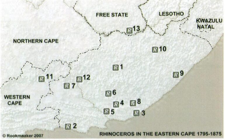
Records of the rhinoceros in the Eastern Cape, South Africa between 1795 and 1875, including one record of theWestern Cape and one of the Free State. Records are numbered chronologically: 1, Tarkaberg (Barrow 1798). 2, Sitsikamma (Barrow 1798). 3, Zuureveld (Barrow 1798); Great Fish River (Lichtenstein 1803; Delalande 1820; Moodie 1830; Bunbury 1838; Backhouse 1838; Black 1848); Zuurberg (Gordon Cumming 1849). 4, Dirkskraal (Paravicini 1803; Lichtenstein 1804). 5, Koega River (Lichtenstein 1804); Addo (Gordon Cumming 1849); Coega River (Hall 1853).6, Modderfontein (Lichtenstein 1804); Agterbruintjeshoogte (Lichtenstein 1804);Baviaans River (Baines 1849).7, Camdeboo (Lichtenstein 1804). 8, Hermannuskraal (Lichtenstein 1804); Fort Willshire (Steedman 1826); Ecca Valley (Hall 1842). 9, Bashee River (Steedman 1830). 10, Transkei (Arbousset 1836). 11, Renosterkop [in Western Cape] (Hall 1842). 12, Graaff Reinet (Murray Family 1866). 13, Kliphuis [in southern Free State] (Baines 1850).
Legend: B, black rhinoceros; R, rhinoceros of unidentified speces; W, white rhinoceros; Z, both black and white rhinoceros.
Based on the research published by Kees Rookmaaker, 2008. Encounters with the African Rhinoceros, p. 128 map A.